Did you know you live on an ancient desert?!

On Saturday I was in the Royal Albert Memorial Museum in Exeter (RAMM) helping to run a specimen handling collection called ‘Local Finds’. It’s a great initiative that brings objects out from the collections of the Museum and makes them available to the public to handle and explore on their own terms, with someone who knows or loves the objects there to talk with the visitor about them. As a volunteer working with the specimens you can choose which mini-collection to work with; animal bones, hand axes (flint tools), seashore items, ceramics, or geology. I, obviously, chose the geology one – both because I know a bit about the specimens selected and I LOVE talking to people about geology (come on it’s awesome!)!!

Local Finds at RAMM

A selection of some of the objects you can handle at RAMM in Exeter.

There are a number of really interesting objects in the geology tray – a lump of cassiterite (a tin bearing mineral that miners in the southwest have searched for for hundreds of years), a piece of pre-victorian slag (or industrial waste – the remains of metal smelting) a bit of limestone with loads of fossils in it, a selection of fossilised shells and invertebrates, and a coprolite. Now for those of you who don’t know, a coprolite is fossilised poo. Additionally, as anyone who has ever talked to children about trace fossils (those fossils that are left behind by the creature, but not the actual remains of the creature – footprints, burrows, tooth marks etc) will know, a piece of fossilised poo is one of the most entertaining things to engage children with about geology and can really highlight how much the child (or adult) knows about fossils. For example, one of the people I spoke to was a little girl, about 8 or 9 years old, who homed in on the fossils on my table like a shark in the water! Picking up the coprolite she said:

Girl: What’s this?

Me: What do you think it is? (again – a science communicator’s favourite question – if in doubt ask this!!)

Girl: Is it a fossil?

Me: It is, what made you think that?

Girl: Um I dunno, it looks like a fossil.

{Interlude – a bit of dancing around what it looked like and what kind of fossil it might be eventually lead us to…}

Me: Well it’s not a normal fossil, clearly and it was found in Lyme Regis. Does that give you any clues, have you been there?

Girl: Oh, is it a coprolite?

{Mum looks over in amazement}

Me: That’s right!

Girl’s little sister: What is a coprolite?

Girl: It’s a fossil poo!!

{Mum looks even more amazed, whilst girls giggle over fossil poo and have a smell to see if it is still smelly, which they eventually decide it’s not, because ‘it’s really old and has become a rock’}

Me: So it’s a fossil poo, from what creature?

Girl: A pliosaur?

At this point the girls’ mother comes over and really gets involved with the interaction. We work out that because the coprolite has scales in it (probably from fish) and because of it’s size, it’s likely from an ichthyosaur rather than a pliosaur. The girls move off to speak to my colleague about some animal bones and I get chatting with the Mum. It turns out she comes from Torquay, near me, and she mentions how she doesn’t always know what to do with her girls’ interest in science – she doesn’t really feel confident in encouraging them and so is frequently surprised by how much they know. She gave the impression that she loves how much they obviously enjoy science, but doesn’t know how best to support them. Luckily Torquay is in the middle of a Geopark – a kind of area of celebration about geology, because it’s really fabulously interesting! Trust me.

The English Riviera Geopark

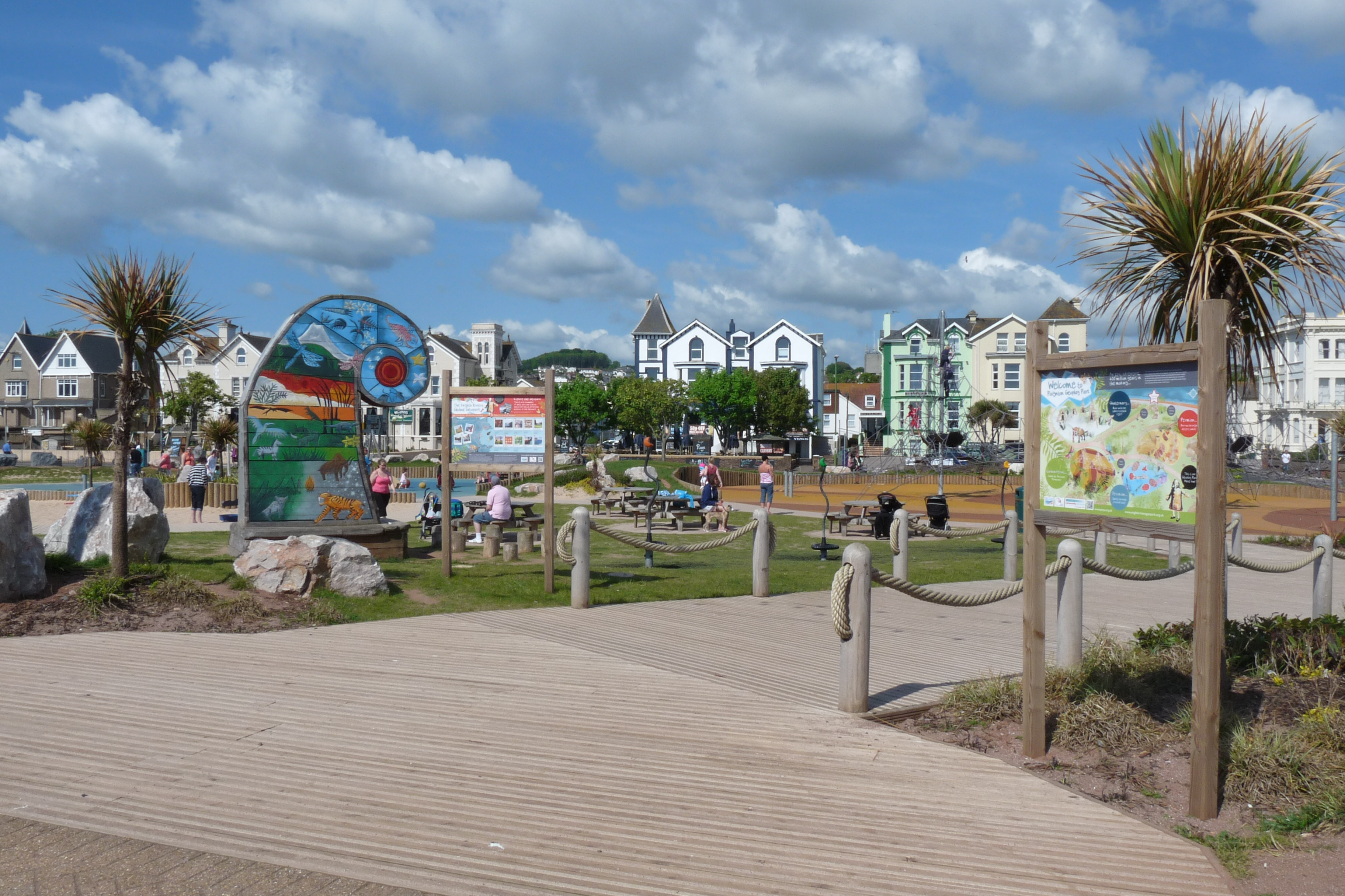
The Geopark has lots of aspects – this is a geo-themed playpark; where was this when I was a kid?! Jealous.

This lead to a discussion of some of the best things to see and do in Torquay if you are into geology, but also made me have a bigger idea. If you could share two geological ideas about your area with someone who is interested, but isn’t sure how to find more, what would they be? For me, Torbay (my immediate area) has two really big selling points. First our sand on the beach is red. Like  a bright ochery orange. I didn’t realise how strange this was as I’ve grown up with it, but some friends who visited me recently were amazed – red sand!

This for me was awesome geo-idea about Torbay number 1

Red sands of Torbay

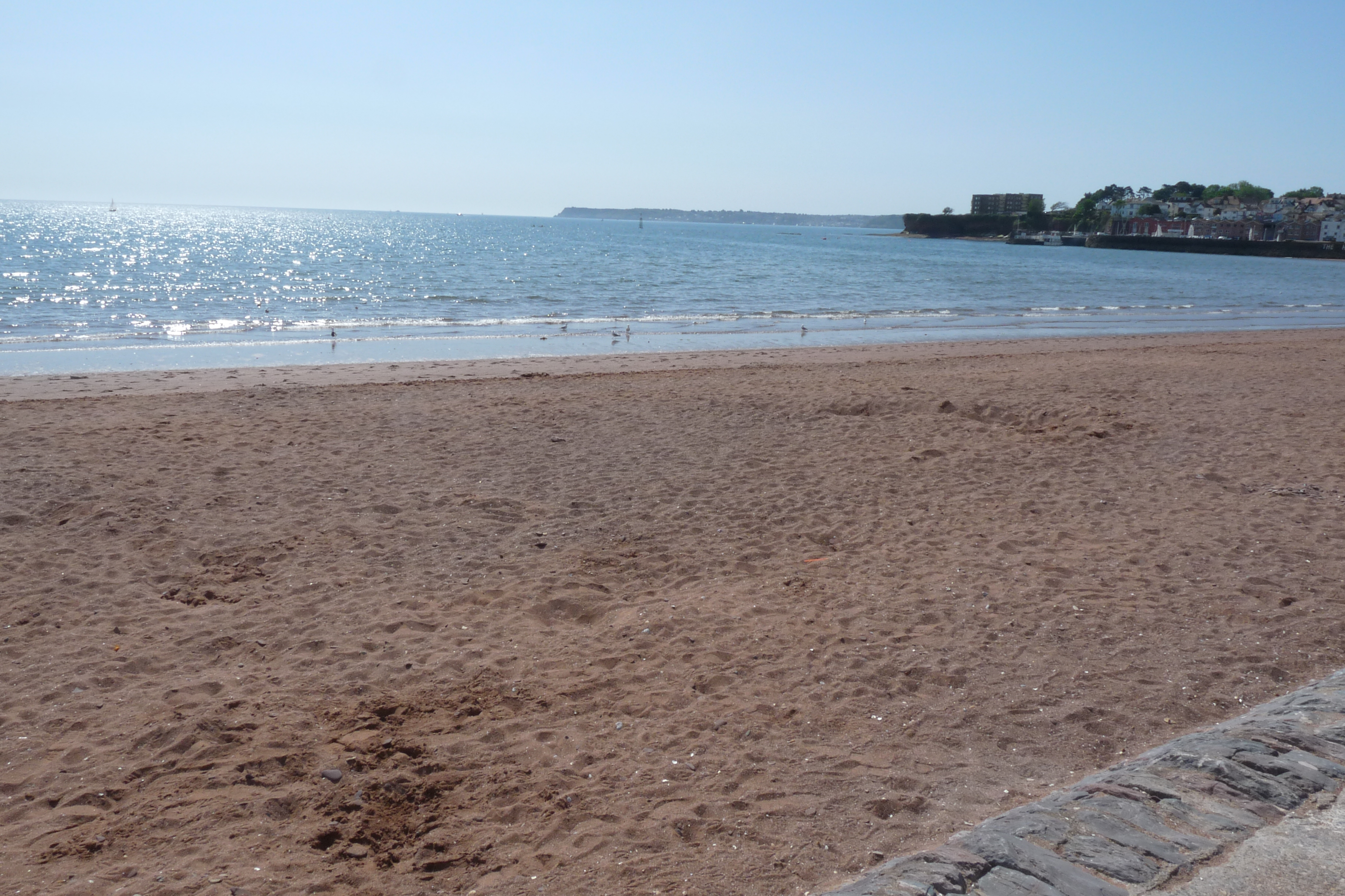
The red sands of Torbay, ok it’s a sunny day which bleaches them out a bit, but you get the idea.

Torbay used to be a desert. A really big desert. And it was a desert for a long time – about 40 million years – from 290 million years ago to 248 million years ago! This for me is one of the great things about sedimentary rocks, you just think about where in the world, today, would you find materials like what the rock is made from and you have a good idea of the environment that existed when the rock started to form. So I was talking to this lady about geology in Torquay and we started talking about the red sand and where else in the world do you see red sand? The Sahara Desert! So by using the idea above, she got the idea that she was living on an ancient desert!

But one idea is not enough, the next idea followed on from this by moving from taking the familiar and realising something unfamiliar, to finding something familiar in a place you would never expect.

Awesome geo-idea about Torbay number 2….

Gold from Hope’s Nose © Ian Jones

There’s gold in them there hills! Yes it’s true. Whilst most of Torbay is characterised by the Red Sandstone rocks deposited during the desert locked Permian Age, the very tip of Torquay headland is limestone, laid down in a warm shallow sea many years before in the Devonian Age (Devon-Devonian, right?). This part of Torbay is called Hope’s Nose. Now aside from a wealth of small fossils, shells, corals and the like, there are a lot of interesting minerals that can be found at Hope’s Nose. Some of these minerals are so unusual that the area has been legally protected and designated a Site of Special Scientific Interest (so the motto if you want to visit is look but don’t touch any minerals you see). One of these unusual mineral is in fact, gold. A strange form of dendritic (meaning plant like) gold has been discovered, right here, in the English Riviera! Now let’s be realistic, it was a very small amount, but it existed – and surely thats exciting? I wonder how many school children in the bay know that one of the most sought after substances in the world may still lie in tiny amounts, right under their noses?! Not to mention brand new mineral discoveries like Chrisstanleyite!

So those are my two favourite ideas about Torbay, an area often shunned by geo-enthusiasts for her flashier coastal neighbour Lyme Regis, or more austere inland aunt Dartmoor, but fascinating to me.

What about you, does your local area have hidden geo-gems?

References:

Paar et al (1998) A new mineral, chrisstanleyite, Ag2Pd3Se4, from Hope’s Nose, Torquay, Devon, England

Russell (1929) On the occurence of native gold at Hope’s Nose, Torquay, Devonshire

Stanley, Criddle and Lloyd (1990) Precious and base metal selenide mineralisation at Hope’s Nose, Torquay, Devon

Warrington and Scrivener (1990) The Permian of Devon, England

How to use a geological map (or where to find an ammonites armour).

When you go fossil hunting, one of the most important things to do is to know what you are looking for. There is no point in looking for a Mammoth skull in a place where the geology is not old enough for Mammoths to be buried there. It’s the same idea as not going fishing in a desert (though geologists sometimes find fish in deserts, but that’s another story). No, in order to know what fossils you expect to find, you need to know about geological maps.

Geological Maps of Britain 1:625 000 Scale BGS

These maps show the bedrock geology – the geology under the soil – for Scotland, Wales, Engand and a bit of Northern Ireland (sorry – overlap is obscuring most of NI)

This is a geological map of Britain. You may realise that it looks a lot like a normal map, except that instead of roads and countryside it has strange bands of colour swirled across it. These bands of colour represent the geology, but I’ll get to that in a minute. First you need to find out where you are on the map.

For argument’s sake I am going to choose Whitby, because I know that is a good place for fossil hunting, but you could start by looking where you live, or somewhere you really want to go looking for fossils (by the way if you don’t have a geology map of your own and can’t find one in your library you can use the digital one on the British Geological Survey website – it’s not as detailed, but you get lots of great extras).

The geology of Whitby

This shows a close up of the geology around Whitby.

So take a closer look at your area. As you can see in this photo the colours on the map around Whitby are:

  • A purpley brown with the letters J1 written in the space
  • An orangey beige with the letters J2-3
  • A light purple with J4
  • A yellow with J5

Which is all well and good, but what does it mean? And how does this help us find our ammonite? Well just to give us context, if we zoom out from Whitby a bit you can see that the nearby area also has greenish bits with ‘K’s on them and pinkish-orange bits with ‘T’s on them.

The geology between Hartlepool and Flamborough Head

This map has zoomed us out a little bit to show some of the other colours in the area.

To find out what this means we need to look at the legend at the side. This is like the key and tells you lots of useful information. Let’s start with what the colours mean.

BGS Bedrock Geology North UK 1:625 000 legend

This is the legend for most of the rocks on this map (there is more but I couldn’t fit it easily on one image)!

Well the first thing that I always notice when I look at the legend of the map is that the colours are all arranged roughly together (there are oranges, blue-greens, beiges, and purples), and that the letters are grouped together as well. So if we think about the ‘J’ letters we were looking at, you can see that they are in the purple-brown section and are linked to an era called Jurassic. This is the geological age of the rocks in this area – it means that all the rocks with a J on them are Jurassic.

This word will probably be familiar to you if you go fossil hunting because here in this country we get a lot of fossils from the Jurassic – including ammonites! So we know we are on the right track. If we look around the Jurassic section, you can see those pinkish-orange colours by the big T are related to the Triassic and the greenish colours above with the K are related to the Cretaceous. Now although you can find fossils in these areas they are a bit far from Whitby, and I think we will find some interesting fossils in the Jurassic age rocks; let’s stick with them.

Zoom in on the legend

This is close up of the part of the legend that relates to Whitby on the map.

So going back to Whitby, if we want to find some fossils we need to know what kind of rocks to look for. Now to start out at the basic level, we already know we need to find a rock made of sediments (mud, sand, clay etc – the sedimentary rocks) because any rock that has crystals in it (like a granite or a marble) can’t have fossils (those are the igneous and metamorphic rocks). I’ll go into that more later, but first we are thinking about Whitby. So if I look back at my map I can see that the rocks immediately around Whitby are purpley brown with J1 on them. If I read that section of the legend it says:

Early Jurassic {  J1   Lias Group  mudstone and limestone

Ok well the first part (Early Jurassic) is just telling us the age of the rocks. This means these rocks are the oldest in the Jurassic period – if you look to the left a little you can see that the Jurassic started approximately 200 MILLION YEARS AGO!! The second is our letter that led us here. The third is the geologist’s name for these rocks – the Lias Group – it helps geologists to link different rocks together and match them across different parts of the country. The fourth part is the most helpful. Mudstones and limestones.

Shale with bivalves and ammonites

This is a type of mudstone – a shale – with lots of little fossils in it.

This tells us the type of rocks we are looking for – mudstones are stones made of mud (obvious huh?) that are brilliant at preserving fossils and limestones are rocks that are pretty much made of fossils. As a quick guide, mudstones are usually grey (especially in this part of the country) and form lots of layers in rocks. They can look a bit like slate but are very easy to break apart. Limestones can be grey, white or cream coloured depending on the fossils, but fossils in them can be pretty small and sometimes are really broken up, so we are going to focus on the mudstones.

So we know where we want to look – Whitby – what era the rocks will be – Jurassic, specifically Early Jurassic – how old they will be – about 200 million years old (specifically between 201-175 million years old) – and what type of rocks we are looking for – mudstones.

So when we go searching here do we know what kind of fossils to expect to find? AMMONITES! Just like Dactylioceras. This means we probably aren’t going to find a mammoth skull here, the rocks are too old! Same for looking for desert rocks, these rocks are too young for that period of our history. So by looking at a geological map you can know what type of fossils you should expect to find.

Geological maps are useful for lots of other things too, but I just want to go back to those bands of colour we saw on the first image. If you are really interested in finding ammonites, but had already looked in Whitby; a geological map can show us where in the country to find rocks of the same age (Jurassic) or type (Lias Group). You see that big purple swathe across the country down to Dorset? Those rocks are all Jurassic. So in theory you could find ammonites anywhere along that line! But remember only some places are safe to collect in, so check before you go running off to your nearest patch of purple-brown!

One final thing to point out is that if you live in certain places you aren’t going to find any fossils. These are places that have igneous or metamorphic rocks and you can spot them on your map initially by looking for the big red blobs.

Igneous provinces in the Lake District

These big red blobs mark where volcanoes used to be and are a sure fire way to find some brilliant rocks and minerals – but no fossils.

Although you are not going to find any fossils in the red blob areas you will find some fantastic volcanic rocks and some amazing and even sometimes really rare minerals and crystals.

If you want to find out more you can check out the British Geological Survey‘s webpage, they have loads of info on the maps they make and even lots of digital ones you can take with you. Check out this pamphlet they produce as well for more in depth information.

BGS - A short Guide to Geological Maps

This pamphlet on geological maps is produced by the BGS.

So there you have it – maps, a geologist’s best friend – and that is how you find an ammonites armour.

Have a rockin’ day!

(this post was moved from my old site, so sorry for any inconsistencies)